
By: Christine Zirneklis and Pablo Herreros Cantis | November 2022
A few hundred years ago your neighborhood was probably a marsh, a stream, or a pond. Now, stronger storms with more rain are hitting New York City more often, and those historical water features have revealed flood-prone areas. Inland neighborhoods can flood too, which more parts of the city are now experiencing.
The Northeast region has seen the largest increase in the amount of water that falls during heavy rainfall in the US, and it’s projected to grow more, according to the fourth National Climate Assessment. Combined with the city’s aging sewer system, that means that if you live in New York City, your home is more at risk of flooding now and in the years ahead.
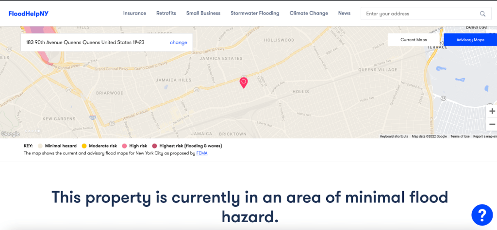
FEMA flood maps, which power the city’s flood prep website, only show coastal storm surge flooding and not the inland flooding that happens when the sewers can’t hold all the rain. The two maps below show a building where the residents of a basement apartment died during Hurricane Ida last year due to flooding. The FloodHelp map shows “minimal hazard,” but the stormwater map shows that up to a foot or more of flooding is likely at the same address. Understanding the risk of both kinds of flooding can be a matter of life or death: you have to check two maps.

To help explain, we talked with Pablo Herreros Cantis, an urban ecologist working on urban climate change adaptation at the Urban Systems Lab. He studies how flood risk disproportionately affects under-resourced communities, and explores methods to better understand where, and how, cities should take action to reduce flood risk. He also works with community organizations likeWE ACT and Groundwork Hudson Valley to co-create projects that meet community needs in the service of climate justice, like the Climate Ready Uptown Plan and the climate safe neighborhoods initiative.
Q: WHY SHOULD PEOPLE THINK ABOUT FLOODING IN New York City?
PABLO: Flooding is a reality in NYC, and it is increasing over time. Looking to the future, the most pessimistic climate change scenarios estimate that the amount of rain that falls during big storms could increase up to another 40%. In New York City, the drainage system was built for the storms of decades ago, and replacing the entire drainage system of the city is basically impossible (though there’s some upgrades planned). Because of this, stormwater flooding in NYC is increasing, and will continue to do so in the coming years due to the effects of climate change. This means that more and more people in NYC will experience flooding, even those who don’t live near the shoreline.
Q: WHY ARE FLOOD MAPS IMPORTANT?
PABLO: So, the first line of defense to adapt to current and future flood risk is to be aware of our exposure to flooding. Facing the reality of our exposure to flooding is the first step to making informed decisions such as refurbishing our homes, anticipating an upcoming storm, or even relocating or making a decision regarding a new home based on its current or future flood exposure. Maps are not perfect, and it can be difficult to understand their limitations. We’ll talk about this too!
Before a storm hits the city, the maps can tell us if we need to take precautions such as moving our valuable items up a floor, or whether we should move out of our apartment temporarily – this is especially important for people living in basements. They can also help us prepare for what comes right after a flooding, by planning to be ready for necessary cleanups that might be required if our homes are flooded. They can also remind us that even if our homes are not impacted by flooding, our lives might still be. Is your usual route to work impacted by flooding? Your fastest trip to your go-to hospital? What is an alternative route you can take in case you need to get to a hospital in the middle of a storm?
Q: WHAT KINDS OF FLOODING EXIST IN NYC?
PABLO: There are two main kinds: coastal flooding and stormwater/inland flooding. Coastal flooding includes storm surge and tidal flooding. A storm surge is when the strong winds of a storm push water towards the land, resulting in higher than normal tide levels. Tidal flooding happens when the tides are higher than the land in low-lying coastal areas. Like all tides, this flooding is controlled by the gravitational pull of the moon and can happen on a sunny day, which is why this type of flooding is also known as “dry weather” flooding. And, storm surge and tidal flooding can happen at the same time. If the tide is high when a hurricane hits, the storm surge will be higher and have worse impacts, like during Hurricane Sandy.
The other main kind of flooding is stormwater or inland flooding, which happens when the amount of rain is more than the drainage capacity of a city’s sewers. And this has worse impacts in areas with more pavement, because the water can’t filter into the ground as it would naturally. Stormwater flooding can also happen when there’s so much water flowing into the sewers that it creates a sewer backup. When this happens, the water will back up to the surface, drain sewage water or is even pushed out through toilets and faucets.
And, sea level rise impacts all of these types of flooding. It has been projected that some locations in NYC could experience tidal flooding twice a day in 2050! And for stormwater, most drainage systems use gravity to transfer stormwater from the streets to nearby water bodies, so when the water levels of the river or ocean are higher than the outfalls of the systems, the water has nowhere else to go and is likely to cause flooding.
HOW CAN PEOPLE IN NYC USE FLOOD MAPS?
PABLO: So we have those two main types of flooding: stormwater flooding and coastal flooding. The best map to understand your home’s risk current and future coastal flooding is NYC Flood Hazard Mapper. It includes several climate change scenarios and both tidal and storm surge flooding. You can also use Flood Help NY, or call its hotline (646) 786-0888 with questions. But be sure to also check your stormwater flood risk using NYC Stormwater Flood Maps. It shows inland flood risk under two different storm sizes, and provides some instructions on what to do if your home is in a flooded area or close to one. You have to check for both kinds of flooding!
And I would encourage people to think about two different risk stages: now, and the future. Maps showing today’s flood risk are useful to evaluate how exposed our homes are today, and consider whether we should adapt them or purchase flood insurance. They also allow us to prepare for upcoming storms by knowing whether we should consider evacuating our home or looking for a relative to host us while the storm passes. And, future flood risk maps can help inform longer term decisions. If we are already exposed, how more exposed should we expect to become? This kind of information is really useful because, while our homes (or a home we are considering to purchase or move into) may not be exposed to flooding today, it might be projected to become exposed sooner than we may think.
